SAVOONGA, Alaska — The National Weather Service in Fairbanks has a Blizzard Warning for St. Lawrence Island from 3 p.m. Tuesday to 3 p.m. Thursday, Alaska time. Blizzard conditions are expected, with 2 to 5 inches of snow and gusts as high as 70 mph. Snow and blowing snow could cut visibility below a quarter mile at times, and the wind could knock out power.
Forecasters say the wind will ramp up through Tuesday night, and the snow arrives Tuesday night into Wednesday as the wind peaks.
A powerful Bering Sea storm
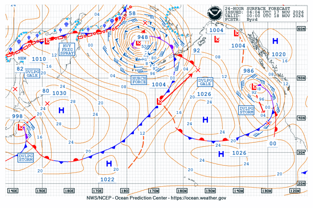
The Ocean Prediction Center’s forecast for Tuesday afternoon shows a 948-millibar low with hurricane-force winds over the Bering Sea. The Fairbanks office says the storm moves north toward the coast, so conditions on St. Lawrence Island and the Yukon Delta coast worsen Tuesday evening and the rest of the west coast worsens overnight into Wednesday. Forecasters expect the low to stall and weaken just south of St. Lawrence Island by Thursday morning.
Hooper Bay’s flood forecast goes up
A Coastal Flood Warning for the Yukon Delta coast runs from 3 a.m. Wednesday to 3 p.m. Thursday. Water could reach 4 to 7 feet above the normal high tide in Hooper Bay, up from 4 to 6 feet in Monday’s forecast, and 2 to 5 feet above it elsewhere along the coast, up from 2 to 4 feet Tuesday morning. Hooper Bay has two high tides on Wednesday, and the second is expected to run slightly higher than the first.
Moderate coastal flooding is likely in Hooper Bay. Roads may close, and use of the airstrip may be limited. Low-lying homes, businesses and some critical infrastructure could flood, and the shoreline may erode. In the worst case, the warning says, fuel tanks could be at risk of flooding.
Blizzard conditions on the Kuskokwim Delta coast
The Weather Service in Anchorage has a Winter Storm Warning for the Kuskokwim Delta coast and Nunivak Island from 3 p.m. Tuesday to 1 a.m. Wednesday. Blizzard conditions are expected there, too, with 1 to 3 inches of snow and gusts as high as 65 mph cutting visibility to a quarter mile or less. Forecasters say the wind could cause extensive damage to power lines. Warmer air Wednesday morning should turn the snow to a mix.
Snow and wind up to Nome
Winter Storm Warnings also cover the lower Yukon River and the Yukon Delta coast from 9 p.m. Tuesday to 3 p.m. Thursday, and the southern Seward Peninsula coast, including Nome, from 3 a.m. Wednesday to 3 p.m. Friday. Two to 5 inches of snow is expected along the lower Yukon and the Yukon Delta coast, and 3 to 6 inches on the southern Seward Peninsula coast, with gusts up to 55 mph. Periods of blizzard conditions are possible, and rain may mix in on Wednesday and Thursday. The office also expects high surf and coastal erosion along the west coast from Kivalina south. The wind should ease by early Friday.
Cities affected
- Savoonga, Alaska
- Gambell, Alaska
- Hooper Bay, Alaska
- Mekoryuk, Alaska
- Nome, Alaska
What to do
- Travel only for emergencies during the blizzard. If you must go, carry survival gear.
- In Hooper Bay, move boats, gear and fuel to higher ground before Wednesday’s high tides.
- Don’t drive or walk through floodwater or around barricades.
- Stay away from downed power lines and report outages to your electric utility.
- Keep phones charged and have a backup way to stay warm in case the power goes out.
Lodi Valley Chronicle publishes a new U.S. weather briefing every morning.